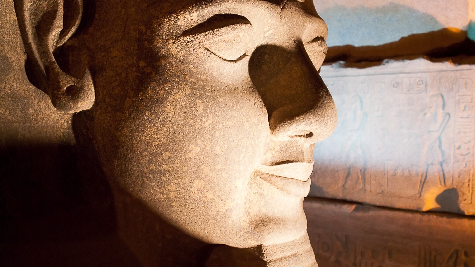
With thousands of archaeological and historical sites on the island, from prehistoric to industrial heritage, and visitor to Sardinia is spoilt for choice. In this article Gianluca, a Sardinian archaeologist, gives us his recommendations for 20 of the best archaeology and history sites for any first time visitor to the island. Seen them all and looking for more places to see and things to do? Then check out our more detailed guides to the different types of sites and museums at the bottom of the page.
- Gianluca Pitzeri
- Last Checked and/or Updated 15 July 2023
- No Comments
- Italy, Sardinia
Sardinia is an ancient land rich in history. Also called the island of towers, because of the more than 7,000 nuraghi in its territory, the Greeks knew it as Ichnussa, because of its shape resembling the imprint of the sole of a foot. The Romans called it Sardinia after Sardus, the hero who, according to legend, occupied the island on his way from Libya. Numerous civilisations have been hosted within its borders over the millennia, and numerous are their testimonies scattered throughout the territory.
From north to south, from the west coast to the east, there is not a spot that is not worth a stop. Each historical and archaeological site manages to convey a unique feeling, accompanied by a sense of continuous discovery, within a beautiful and unspoilt landscape.
Of course, in addition to these 20 places, which are meant to be an introduction to what the island has to offer, there are many that have been left out, and which nonetheless deserve great attention. Follow the links at the bottom of this page for more ideas of places to visit in Sardinia.
The invitation is to discover this land, which, with its thousand-year-old history, its traditions, its typical dishes, and its breath taking landscapes, will make you fall in love.
Map of Archaeology & History Sites in Sardinia
The following map only pinpoints the location of the places mentioned on this page. For a more complete map showing all our listed and recommended attractions in Sardinia, see our Interactive Map of Sardinia.
New to the Archaeology Travel website? Those who have an account (free of charge) can create personal travel lists and itineraries. Once logged in to your account, you can easily add any or all of the archaeological and historical sites on this list to your own itinerary or travel lists. At the end of this page you will see a checklist, from which you can select the sites you would like to visit.
To learn more about how to benefit fully from the various travel planning features on this website, see the User’s Guide.
Map of must-see archaeology & history sites in Sardinia
Su Nuraxi of Barumini
Su Nuraxi of Barumini is the most famous nuraghe in Sardinia. Built from the 16th century BC onwards, it represents one of the power centres of the ancient Nuragic civilisation.

Su Nuraxi is undoubtedly one of the most representative sites of Nuragic society. It is not yet certain whether these complexes were command centres, fortresses for controlling the territory, or residences for the most important families. What is certain is that they were imposing structures.
It is located in the Marmilla region, in the municipality of Barumini, on a hill overlooking the plain below. It was brought to light between 1950 and 1957 by Giovanni Lilliu, a leading figure in Sardinian archaeology, and in 1997 became part of the Unesco World Heritage Site, of which it is still the only archaeological site on the island.
For more than 2000 years, the site has seen continuity of life, starting in the 16th century BC, when the 18 m high central tower was built, and later, surrounded
by four other towers.
Between the 9th and 6th centuries BC, above the remains of the now collapsed nuraghe, a village arose that represents an exceptional case in terms of the complexity of building techniques and types of dwelling, the contacts that existed with the rest of the Mediterranean civilisations. The area was frequented until the Roman period in the 3rd century AD and sporadically until the 7th century AD. The visit is something that leaves an indelible mark, between the amazement at the massive Nuragic architecture, and the continual sense of discovery that walking among these ancient ruins restores.
Tharros

The city was built on an area that had previously hosted the Nuragic civilisation, of which important traces remain throughout the area. Later, the Phoenicians, around the end of the 8th century BC, settled on the peninsula, founding an emporium. To the Carthaginian period (late 6th century BC – 238 BC), belong some of the most beautiful and peculiar artefacts, found within the Punic chamber tombs. No other centre in Sardinia has yielded such a quantity of precious objects, a fact that testifies to the great importance it must have possessed, both in the commercial trade of the ancient Mediterranean and in the manufacture of such artefacts on site.
The Romans, particularly in the imperial period, proceeded to monumentalise it, modifying its ancient layout. The centre suffered a slow decline during the raids on the Sardinian coast by the Saracens (8th century AD), leading the population to abandon the area. Around the middle of the year 1000 AD, the episcopal seat was moved to nearby Oristano, located in a more inland and sheltered area, putting an end to the life of the ancient centre. Unfortunately, its ruins became the destination of numerous grave robbers between the 17th and 19th centuries, in search of the precious treasures kept inside the tombs. Many figures and artefacts were lost, while others were scattered among public and private collections, including some important pieces on display in the British Museum.
Tharros is certainly one of the most representative and iconic places on the island, capable of making people fall in love with itself thanks to its fantastic views, which create a unique mix of nature and history.
Monte D'Accoddi
The so-called ‘Sardinian Ziggurat’, built between 4000 and 3200 BC. The structure is a unique example of a reference to Mesopotamian temple structures in Europe.

About 11 km from Sassari, on the road to Porto Torres, is this small wonder built in the Recent Neolithic.
It was discovered in the 1950s, and in the 1980s the western part was rebuilt in ways that still do not fully convince experts. The temple has two construction phases: the first, dated between 4000 and 3200 BC, sees the construction of the so- called ‘red temple’, so called due to the presence of plaster and red paint on the floor, later incorporated by the subsequent redevelopment of the area; the second between 3200 and 2700 BC. in which the new temple structure was built, in an area occupying 1600 square metres. This must have been about 8 metres high, in the shape of a truncated pyramid, accessible via a 40-metre-long ramp, culminating, after a short flight of steps, in the open-air terrace. All around, there was a village that predated the temple, not yet completely
excavated.
Within the European panorama, this structure represents a unique case, harking back to the approach and ideology of the Mesopotamian Ziggurats. Obviously, both the construction techniques and the dimensions are different, but it still appears as a place where the community gathered, to celebrate propitiatory rites linked to fertility, in a place that put the earth in direct contact with the sky.
Temple of Antas

In the territory of Fluminimaggiore, in a verdant valley immersed in total tranquillity, lies the Temple of Antas. The building is one of the most distinctive and representative on the island. Earlier, a first sacred building was built around 500 BC by the Punic, in honour of the god Sid Addir, the same divinity that we find in the cities of Tyre and Sidon located on the Libyan coast. In 38 BC. Augustus wanted to build a new temple in honour of the deity of the Sardinians, i.e., Sardus Pater Babai, perhaps also to remove traces of the previous Punic cult, assimilating it into the new Roman one.
The area was already known in ancient times for the wealth of its mineral resources, particularly iron and lead, giving the construction of the temple a clear strategic significance for the control of these raw materials. It was restored at the behest of Emperor Caracalla between 213 and 218 AD but what we see today is the result of a reconstruction in 1967, when the first excavations took place. The discovery instead took place in 1836 by General La Marmora, who was unable to excavate due to lack of means. In the immediate vicinity, there are traces of Roman quarries and a Nuragic village, testifying to the ancient frequentation of the area. Finally, it is also possible to reach the nearby Su Mannau caves on foot, following the ancient Roman road.
Basilica of San Simplicio in Olbia

The church, in 1993 given the status of minor basilica by Pope John Paul II, is dedicated to the patron saint of the city of Olbia, and stands on a small hill once outside the urban circuit of the old town.
Saint Simplicius died a martyr’s death on 15 May 304, and near his burial place, as was often the case in the early periods of Christianity, a cemetery was built on which the church was later erected. It was probably built at the behest of the Judges of Gallura, between the second half of the 11th and the beginning of the 12th century. The patron saint’s festival, one of the most evocative and heartfelt on the island, takes place in the week of 15 May.
The church is one of the major representatives of the Romanesque style throughout Sardinia, which spread more generally throughout Europe between the 11th and 12th centuries. It is built of local granite and has a three-nave layout, with an apse to the north-west, on which two frescoes remain, now faded, depicting St Simplicio and St Vittore. Under the altar, the Saint’s relics, discovered in 1614 during excavations of the crypt, are kept in a reliquary.
The entire area is also of great archaeological interest, as 450 Roman tombs dating from 200 BC to 300 AD have been found in the excavations in front of the basilica, as well as other necropolis and cult areas, covering the earliest phases of the city from the Phoenicians to the medieval period.
Romanzesu Archaeological Site

Within a forest of cork trees, in the territory of Bitti, which appears almost enchanted by the way the ruins of the ancient settlement blend into the vegetation, lies the archaeological area of Romanzesu. It is a village-sanctuary from the Nuragic period, built around the 16th century BC. It owes its name to the presence of the Romans who decided to settle here between the 2nd and 3rd centuries AD.
The site has some unique structures, providing visitors a glimpse into certain aspects of Nuragic sacredness. Extending over 7 hectares, there are some 100 huts and various cult buildings. Connected to the sacred well was a sub-elliptical basin with several rows of steps, which had both the purpose of collecting the excess water from the well and of housing the community during ceremonial moments linked to the water cult. The hut of the labyrinth is certainly one of the most impressive, leading to the central sacred room via a sort of ritual pathway, formed by three rows of concentric walls with staggered entrances. Finally, the hero’s tomb consisted of a sealed central chamber, which yielded bronze weapons inside, but no burial, suggesting that it represented a kind of symbolic place of worship. These sites perfectly convey the great importance that the Nuragic civilisation gave to the sacred sphere, around which this village seems to gravitate.
Medieval Walls of Alghero

The beautiful city of Alghero, located on the north-western Sardinian coast, was founded according to tradition in the early 1100s, by the Genoese Doria family. The walls were erected shortly afterwards, towards the middle of the 12th century, in an initial arrangement that counted 26 towers. After the seizure of the city by the Aragonese, in the various events that took place between 1353 and 1354, in the 16th century, it was decided to rebuild the walls, in order to adapt to the new defensive requirements due to new artillery systems.
In 1867, the city ceased to be considered strategic, a fact that should have led to the complete dismantling of the wall circuit, but fortunately only led to the removal of the fortifications of the land line. There are eight towers visible today, the most famous of which include the Torre di Porta Terra, once the point of access to the city for those arriving from Sassari, saved from demolition in 1867, and the Torre di Sulis, named after a tribune from Cagliari who, being famous for fomenting riots, was sentenced and imprisoned inside for 20 years around the 18th century. The walls of Alghero are a wonderful place full of history that, for almost 900 years, have enchanted those who walk along them and sustained the city.
Necropolis of Monte Siseri

The tomb, nicknamed s’Incantu, but also known as the Tomb of Painted Architecture, is located in the territory of the municipality of Putifigari, in the province of Sassari, and is part of a small necropolis complex located on Monte Siseri, composed of four Domus de Janas in total.
S’Incantu is undoubtedly a small gem, for the technical, decorative and architectural level of its forms. It was discovered in 1985 and investigated in 1989. The period of its construction is between 3200 BC and 2600 BC, which places it as one of the high points of Sardinian Neolithic art. A long dromos gives access to a small atrium, followed by the central cell, onto which the two side cells open for the deposition of the dead. The central cell, two metres high, features two columns supporting a double-sloping ceiling, where fake wooden planks, alternately coloured black and red ochre, are carved in relief.
There is also a symbolic bonfire, represented by five concentric circles in the centre of the room, where offerings dedicated to the deceased were once placed. In the cell and the anti-cell there are symbols related to the funerary world, such as false doors and taurine protomes of a very high technical level. All these elements, as one enters the chamber, seem to transport the visitor into the sacred and symbolic world that the authors of the tomb of s’Incantu wanted to convey.
Roman Amphitheatre in Cagliari
Within the city of Cagliari, in a perfect symbiosis of the ancient and the modern, lies one of the most impressive works remaining in Sardinia from the Roman Empire, the Amphitheatre.

The Roman Amphitheatre of Cagliari, built between the end of the 1st and the beginning of the 2nd century AD, was partly excavated in the rock, on the southern slopes of the Buon Cammino hill, within the ancient valley of Palabanda.
In its heyday, during the festive days of the Roman civilisation, when various types of ‘games’ were hosted, such as ludi gladiatorii or venationes (wild animal hunting competitions), it must have held around 8000 people. The front part of the entrance was built entirely of masonry, being the only part that did not rest on the rock face, and must have reached a height of about 20 metres.
During the medieval period, the whole area was subjected to heavy spoliation that deprived the building of its precious decorations, turning it into a simple architectural skeleton. The Amphitheatre is a symbol of the city of Cagliari, which has been able to change its functions according to the needs of the populations that have inhabited it over the centuries. Used for residential purposes in the post-war period, it was later used as a theatre for performances and concerts, while efforts are currently being made to secure the internal areas in order to bring it back to life by sharing its spaces with the public. If you are in Cagliari, you absolutely cannot miss the opportunity to admire it together with the beautiful city panorama, during a wonderful walk in the area.
More about the Roman amphitheatre in Cagliari
See more photographs and further information about visiting the Roman Amphitheatre in Cagliari.
Find more Roman Sites & Museums in Sardinia.
The Nuragic Sanctuary of Santa Vittoria
In the Giara of Serri, a plateau 650 metres above sea level, the most important sanctuary of Nuragic Sardinia is preserved, capable of astounding visitors.

The Nuragic sanctuary of Santa Vittoria is located in the territory of Serri, on the border between the Sarcidano and Trexenta areas, on a plateau that in Sardinia is called Giara. The area offers a splendid view of the entire surrounding landscape, ranging from the Gennargentu mountains to the hills of Marmilla.
The name of the site derives from the ancient small church in honour of Santa Maria della Vittoria, probably built in Byzantine times, although it was later modified. The Nuragic sanctuary is distinguished by the size of the area and the uniqueness of the various structures. There is an ancient proto-nuraghe (17th – 14th century BC), later incorporated by a more recent nuraghe (13th – 12th century BC); a well temple, dating back to the 9th century BC, of exquisite workmanship, presents a bichromic structure with basalt and limestone blocks. In the nearby hypetral temple, into which excess water from the well was discharged, forming a basin for ritual ablutions, the famous bronze statuette of the village chief was found (now in the Archaeological Museum of Cagliari).
Also of great interest is the great feast enclosure, a huge complex built to accommodate pilgrims who came to the sanctuary in honour of the deity. The whole area deserves a thorough visit, as there is so much to see and discover, in a place that will surprise and amaze you.
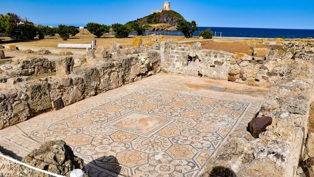
Ancient City of Nora
The ancient city of Nora, set in the crystal-clear waters of the Mediterranean Sea, is a landmark in the Sardinian archaeological landscape, frequented since antiquity by different peoples, who have contributed to enriching its history and importance.

Nora was founded on a small peninsula on the south coast of Sardinia, to which it is joined by a narrow line of land. It is located in the territory of Pula, a beautiful town of medieval origins, which probably originated after the abandonment of the ancient city. It is surrounded on three sides by the Mediterranean Sea, which not only created a wonderful atmosphere for visiting the archaeological site, but also slowly incorporated part of the ancient settlement, which now lies below the sea.
The area was first inhabited by Phoenician peoples (7th century BC), becoming a real city from the Punic period, around the end of the 6th century BC.
Under Roman rule, the city grew and beautified, from the moment it was given the status of Municipium in the 1st century BC. The urban centre reached its constructive and architectural peak during the imperial period, around the 4th century AD. It housed within its boundaries structures of all kinds, such as the aqueduct, the amphitheatre, the forum, the theatre and the various temple and spa structures necessary for city life. Abandonment occurred around the 8th century AD, at a time when the coast of Sardinia was a constant target of Saracen piracy.
Nora is one of the most popular day-trips from Cagliari, particularly as a shore excursions for cruise ships docked in Cagliari. A visit to the ruins of the ancient city of Nora, where archaeology, sea and nature create a unique ensemble, will engage and enthral you with its beautiful views.
More about the Archaeological Site of Nora
See more photographs and further information about visiting the Ancient City of Nora, including details for day trips and shore excursions.
Find more Roman Sites & Museums in Sardinia.
Holy Trinity of Saccargia

The Basilica of the Holy Trinity of Saccargia is located in the municipality of Codrongianos, in the province of Sassari, and dominates the verdant plain of Saccargia from the top of a rocky spur on which it stands. The name Saccargia, according to various hypotheses, could derive either from the word “sacraria”, for the ancient sacred value attributed to the area since antiquity, or from the Sardinian word “s’acca argia”, meaning the spotted cow that, according to legend, appeared every day in front of the monastery, kneeling to be milked by the monks.
The church is the highest expression of Romanesque in Sardinia. Built by Pisan-Pistoiese workers, it saw a first phase just before 1112, then consecrated in 1116 and completed in a second phase in the second half of the 13th century. It was built by Judge Constantine I of Torres, who, after making a sacred vow with his wife Marcusa de Gonale to have a son, donated it to the monastery of Camaldoli in 1112 following the birth of Gonario II. The basilica is splendid, presenting an alternation of two colours due to the use of white limestone and black basalt stones, with a length of 30 m and a height of 14 m. The plan is in the shape of a commissa cross and has a single nave ending in an apse, in which a 12th century fresco has survived to this day, depicting a complex pictorial cycle, created by Tuscan-Latvian craftsmen.
The magnetism that this imposing and beautiful building manages to convey is something indescribable, attracting numerous visitors. Just catching a glimpse of the bell tower from afar, the urge one feels to visit it is irrepressible.
Malaspina Castle

The Malaspina Castle, or also known as Serravalle Castle, the name of the hill on which it stands, is located in the municipality of Bosa. Since its construction, it has played a very important strategic role, being a lookout and control area on the river Temo. Although its construction is customarily dated back to 1112, when the area was included in the Judicate of Torres, the first archaeological data attest to it, in accordance with historical sources towards the middle of the 13th century, having passed by marriage dowry in 1232 into the hands of the noble Malaspina family, of Tuscan origin.
The castle changed hands several times: to the judges of Arborea in 1317, then to the crown of Aragon towards the end of the 15th century. From the 16th century, it began a slow decline in favour of the nearby Alghero, populated by Catalans. Inside the walls, you can admire the palatine chapel, built around the 13th century, then dedicated towards the end of the 19th century to Our Lady of Sos Regnos Altos, where a splendid cycle of 14th-century frescoes is preserved, which came to light during consolidation works. From the castle walls, you have a marvellous view of the colourful and lively town of Bosa, which, with the medieval quarter of Sa Costa, built directly under the castle walls between the 13th and 15th centuries, will amaze you with the picturesque colours of the houses overlooking the river.
La Prisgiona Nuragic Complex

The nuragic complex La Prisgiona, is located in Gallura, the North-Eastern region of Sardinia, in the territory of the municipality of Arzachena. It is located on a rise overlooking the Capichera valley, framed by a panorama of vermentino vineyards and Mediterranean scrub vegetation, which gives an unmistakable imprint to the entire area. The complex dates back to the 14th century BC, while it fell into ruin around the 8th century BC.
The nuraghe, composed of a central tower and flanked by two lateral towers, connected by a rampart, is surrounded by a village occupying about 5 hectares, consisting of about a hundred huts. The size and construction techniques of the latter not only leave one astonished, but also allow one to understand the importance that the centre must have held in those times, a probable pole of attraction for the populations of the area. The various structures investigated in the village allowed us to learn how each block carried out a different production or craft activity, and how the consumption of wine was already a practice. We are faced with a unicum for the Gallura region, as there are no similar structures of this architectural complexity.
A visit to the site is certainly one of the best that Sardinia has to offer, allowing, by means of a system of footbridges, a comfortable walk in retracing the history and paths of the Nuragic people who lived here more than 3,000 years ago.
Mount Sirai
At the top of a hill that dominates the entire surrounding landscape, from which there is a breath taking panorama, you can visit the only site in Sardinia that has maintained intact the urban layout of the Punic period.

The archaeological site of Monte Sirai, in the territory of Carbonia, is located on a high plateau that dominates the Sulcis territory, in the south-west of the island, and offers a unique and wonderful panorama. The area has been frequented since antiquity by Neolithic and Nuragic peoples, who have left various signs of their presence, one of the most significant being the Nuraghe Sirai nearby. The Phoenicians, around 750 BC decided to found a centre, which with the conquest of the island by the Carthaginians towards the end of the 6th century BC, saw the presence of a new social group.
The uniqueness of this little gem of Sardinian archaeological heritage, is that it is the only site that is presented with its Punic layout, since it was abandoned around 110 BC and never underwent redevelopment by the Romans. It was discovered in 1962 by a young boy from Carbonia, leading to the start of excavation investigations in the following year.
The archaeological area allows you to visit the settlement, where you can admire what remains of the Punic houses and the ancient temple, in honour of the goddess Astarte, built on the foundations of an earlier Nuraghe. It is possible to visit the necropolis area, where some chamber tombs dug out of the rock can be accessed, while the Tofet area is currently not accessible. For a more complete experience, in nearby Carbonia is the Villa Sulcis Archaeological Museum, where many beautiful objects from the site are on display.
Serbariu Coal Mines
The mining site of the now disused Serbariu Coal Mines, was between 1937 – 1964 not only the driving force of the Sulcis economy, but also one of Italy’s most important energy resources.

The Sulcis area has always been rich in mineral resources, a fact that has led numerous peoples to settle there in order to exploit its wealth. The mines came into being following several soundings that made it possible to locate a large coal deposit in 1936, during the events of the Second World War. The town of Carbonia was founded in the 1930s, precisely to house the miners and the professionals needed for the mine’s activities. These reached imposing dimensions, with over 100 km of tunnels and a depth of 103 metres below sea level. In its almost thirty years of activity, it reached 18,000 employees, then 5,000 shortly before it was decommissioned, leading to major and famous strikes, including one in 1948 that lasted 72 days. It was officially closed in 1971, only to be revived with the construction and opening of the current Coal Museum in 2006.
This has enabled the recovery of buildings and equipment from the original mine for educational purposes, leading to the creation of exciting content on mining activities. It will also be possible to visit part of the old underground gallery, in a faithful reconstruction of the original mine environment, and the winch room, in which the machinery for the descent and ascent of miners into the shafts is preserved.
Necropolis of Sant'Andrea Priu

On a plain near the municipality of Bonorva, in the province of Sassari, rises a very important necropolis related to the pre-Nuragic burial world, dated between the Recent Neolithic and the Eneolithic (3200 – 2850 BC). It consists of 20 hypogea, excavated in a rocky trachyte bank, some 2 – 3 m above ground level. Among them, three Domus de Janas stand out, which present a completely different technical level from the others.
The Chamber Tomb, and the Circular Hut Tomb, represent in their decorations, elements that are reminiscent of civil huts, and which help us to imagine what these must have looked like. The most striking is undoubtedly the Tomb of the Chief, one of the largest hypogea in the Mediterranean, a 250 m2 Domus de Janas with 18 rooms arranged in an almost labyrinthine fashion. The central part is composed of an atrium that gives access to two other rooms located one behind the other, onto which other small cells open. This is the hypogeum where the forms and decorations engraved on the rock meet and mingle with Christian art.
The tomb, at the dawn of Christianity, was used as a proper church, repeatedly plastered and frescoed with scenes from the New Testament between the 4th and 6th centuries AD, and probably also in the 8th century. In 1313 it was dedicated to St Andrew, after whom the entire necropolis is named.
Roman Baths of Fordongianus

The centre of Forum Traiani, where the baths were built, was probably founded in the late Republican age under the name of Acquae Ypsitanae, only later taking the name of Forum Traiani, with the granting of the status of City Hall by Emperor Trajan, between 98 and 117 AD.
The entire area appears to be closely linked to the cult of water, as evidenced by the discovery of several inscriptions dedicated to the Nymphs, and others dedicated to the god Bes/Aesculapius, a deity associated with healing, to whom two small statues representing him should be referred.
The date of construction of the first facility is uncertain, perhaps between the end of the 1st century AD and the beginning of the 2nd century AD. The complex originated from a large rectangular stepped pool, which was called natatio, and into which thermal water with a temperature of 54°C flowed. On the long sides of the pool were two porticoes, one of which was connected to the second bathhouse, at a slightly higher level than the first. This was built in the 3rd century AD, and has the typical room composition associated with Roman baths, divided into frigidarium, tepidarium and 2 calidaria, in which the water did not come from the thermal spring, but was heated normally.
Immediately to the south of the second thermal baths, a large paved square is preserved, from which a flight of steps that must have led to the ancient settlement originates.
Biru'e Concas Archaeological Park

In the territory of Sorgono, in the historical region of Mandrolisai in the centre of the island, is the archaeological park of Biru’e Concas, which can be translated from Sardinian as ‘the path of the heads’. It is located on the hill of Coa’e sa Mandara, in an area covering 770 square metres, within a forest of holm oaks and cork trees. The complex is dated between the final phases of the Recent Neolithic and the Eneolithic (4th and 3rd millennium B.C.).
The site was first archaeologically investigated in 1994, with investigations focused in particular on the search for the settlement, which was not found, but which in return returned numerous materials necessary to date the area. This large concentration of menhirs, inserted by cutting into the earth, are found arranged in various ways: in groups of two or three, in circles or in lines one after the other, and in one case 30 of them are arranged in a double row. The types are simple, mainly proto-anthropomorphic with a flat face and convex back, while two particular ones stand out: an anthropomorphic one, with a slight representation of the eyes and nose, and a statue-menhir with a face depicted and a dagger at the waist. In addition to the menhir, there are also the ruins of a Nuraghe in the area, and the remains of a large megalithic wall dating back to the mid-Eneolithic period (2400 – 2100 BC), which it is assumed, at the current state of research, must have encircled an area of 1600 square metres.
Eleonora d'Arborea's Castle

The castle of Eleonora d’Arborea, in the municipality of Sanluri, occupies the area of Medio Campidano, below the heights of Marmilla, in what was once a strategic point on the border between the Judicates of Cagliari and Arborea. Currently, the most probable date of its construction is thought to be between 1188 and 1195, when it commissioned by Judge Pietro I of Arborea to defend his territories against the neighbouring Judicate of Cagliari.
It was later enlarged and completed in the mid 14th century by Pietro IV of Aragon. The castle is named after one of the leading figures in Sardinian medieval history, although it does not appear that Eleonora d’Arborea actually stayed in the castle. The building was witness to events that marked Sardinian history, such as the signing of the Peace of Sanluri, in 1355, between the Crown of Aragon and the Judicate of Arborea, and the Battle of Sanluri, in 1409, which decreed the end of the Arborean Kingdom, in favour of Martin I of Sicily, heir to the Crown of Aragon. During the battle, a detachment of the Arborense army sought shelter inside the fort, but unable to resist the enemy troops, over 600 soldiers lost their lives.
Later, the castle lost its strategic and defensive functions, eventually becoming a simple residential structure, changing hands several times until the current ownership of the Counts of Villa Santa. Today, it houses the Museo Risorgimentale Duca d’Aosta, commissioned by the Duke of Aosta Emanuele Filiberto in 1927 as a tribute to the Sardinians who fell in the war for the unification of Italy, housing various historical relics.
Add these Sites to Your Sardinia Itinerary & Travel Lists
If you are planning a trip to Sardinia you can use our itinerary builder to create your own travel lists (such as places you have been to, places you would like to visit) and itineraries. These can also be shared with your friends, privately and on social media. To make use of this feature, however, you will need to login or register as a new user. Registering to use our itinerary builder is free of charge.
Use the checklist below to add any or all of the sites mentioned above. Simply select the sites you want to visit by checking the boxes, or check the ‘select all’ box at the top of the list. To find more sites to visit in Sardinia, consult our Sardinia Travel Guide. Or consult the A – Z list of Art, Archaeology & History Sites & Museums in Sardinia, Italy.
- Su Nuraxi di Barumini
- Tharros Archaeological Site
- Mount d'Accoddi
- Antas Archaeological Area
- Basilica of San Simplicio, Olbia
- Romanzesu Archaeological Area
- Alghero Medieval Walls
- Domus de Janas S'incantu - Necropolis of Monte Siseri
- Roman Amphitheatre, Cagliari
- The Nuragic Sanctuary of Santa Vittoria
- Nora Archaeological Site
- Holy Trinity of Saccargia
- Malaspina Castle
- Nuraghe la Prisgiona
- Mount Sirai Archaeological Park
- Serbariu Coal Mines Museum
- Necropolis of Sant'Andrea Priu
- Roman Baths of Fordongianus
- Biru'e Concas Archaeological Park
- Eleonora d'Arborea Castle
Archaeology Travel Writer